Miami’s free trolley system offers a convenient and cost-effective way for residents and visitors to navigate some of the city’s most vibrant neighborhoods, including Downtown, Brickell, Wynwood, Little Havana, and Miami Beach. Operated by several municipalities, this network of air-conditioned, vintage-style vehicles runs daily, aiming to reduce traffic congestion, improve local mobility, and provide an accessible link to major cultural, commercial, and transit hubs. By simply locating a designated stop and hopping aboard, passengers can explore the Magic City’s top attractions without spending a dime on transportation.
How the Trolley System Works
While the idea of a free city-wide transit system might seem complex, using Miami’s trolleys is remarkably straightforward. The system is designed for ease of use, with clear signage and modern tools to help you plan your journey.
Finding a Stop
Trolley stops are clearly marked with official signs that typically feature the trolley logo and route information. In many areas, especially within the City of Miami and Miami Beach, these stops are co-located with Miami-Dade Transit bus stops. Look for the distinct trolley sign, which is often attached to the same pole as a Metrobus sign, making it easy to identify your pickup point.
Stops are generally located every few blocks along a route, ensuring you are never too far from a convenient boarding location. In high-traffic areas like South Beach or Downtown, you will find them even more frequently.
Boarding and Riding
Boarding the trolley is the easiest part: it is completely free. There are no tickets to buy, no cards to tap, and no fares to pay. When the trolley arrives, simply wait for passengers to disembark and then step aboard through the front door. The experience is designed to be as seamless as possible.
All trolleys are ADA-compliant and equipped with wheelchair lifts or ramps, making them accessible to all passengers. Priority seating is designated at the front of the vehicle for seniors and individuals with disabilities.
Tracking the Trolleys in Real-Time
To eliminate guesswork and long waits, each major trolley network has a dedicated mobile app for real-time tracking. These apps are essential tools for any trolley rider, showing live maps of where each vehicle is, estimated arrival times for your stop, and any service alerts.
Before you head out, be sure to download the correct app for the area you plan to explore:
- City of Miami: Search for the “City of Miami Trolley” app.
- Miami Beach: Search for the “Miami Beach Trolley” app.
- Coral Gables: The “City of Coral Gables” app includes a trolley tracker.
Navigating the Different Trolley Networks
A common point of confusion for first-time users is that the “Miami Trolley” is not a single, unified system. Instead, it is a collection of separate services operated by different municipalities. While they often connect, they are managed independently and cover distinct geographic areas.
The City of Miami Trolley
The City of Miami’s network is the largest, featuring its signature orange-and-green trolleys. It connects a wide array of neighborhoods, making it invaluable for exploring the mainland. Its routes are designed to link residential areas with commercial centers and major attractions.
Key routes include the Brickell Route, which loops through the dense financial district; the Wynwood Route, providing direct access to the world-famous street art scene; and the Little Havana Route, which runs along the iconic Calle Ocho (SW 8th Street). Other routes serve areas like Coconut Grove, Overtown, and the Health District.
The Miami Beach Trolley
Instantly recognizable by their blue-and-white design, the Miami Beach trolleys are a visitor’s best friend. This system exclusively serves the barrier island of Miami Beach, offering a fantastic way to get around without the hassle of expensive parking and traffic.
The network is broken into several loops. The South Beach Loop is perfect for tourists, making stops near Ocean Drive, Lincoln Road Mall, and the Art Deco Historic District. For longer trips, the Collins Express provides faster service up and down the island, while the Middle Beach and North Beach Loops connect hotels, parks, and residential areas further north.
The Coral Gables Trolley
Reflecting the city’s historic aesthetic, the Coral Gables trolleys are designed to look like classic early 20th-century streetcars. This service primarily functions as a commuter link, connecting the city’s business district along Ponce de Leon Boulevard with the Douglas Road Metrorail station.
While aimed at local workers, it is also a charming way for visitors to explore the “City Beautiful.” You can ride it to access the shops and restaurants on the famous Miracle Mile or to connect seamlessly with Miami’s broader Metrorail system for trips to Downtown or the airport.
Strategic Routes for Visitors
With a little planning, you can use the trolley system to create a full day of sightseeing. Here are a few popular itineraries that leverage the free service.
The Art & Culture Connector: Wynwood and the Design District
Start your day by taking the City of Miami’s Wynwood Route. Hop off near the Wynwood Walls to immerse yourself in one of the world’s largest outdoor art galleries. After exploring the murals, you can either walk or take a short rideshare to the nearby Design District to experience its high-fashion boutiques and public art installations.
The Sun & Sand Circuit: Exploring Miami Beach
Use the Miami Beach Trolley’s South Beach Loop as your personal hop-on, hop-off tour bus. Start with a morning stroll along Ocean Drive, then hop on the trolley to head to Lincoln Road for some shopping. In the afternoon, ride it back toward the southern tip of the island to visit South Pointe Park for stunning views of the ocean and Fisher Island.
The Downtown & Brickell Loop: Skyscrapers and Bay Views
Combine the City of Miami’s Brickell and Biscayne trolley routes for a tour of the city’s urban core. Ride through the towering skyscrapers of Brickell, then connect to the Biscayne route to visit Bayfront Park, the Kaseya Center, and the Pérez Art Museum Miami (PAMM). For an elevated view, hop off at a stop that connects with the free Metromover, an automated light rail that loops around Downtown and Brickell.
A Taste of Cuba: The Little Havana Route
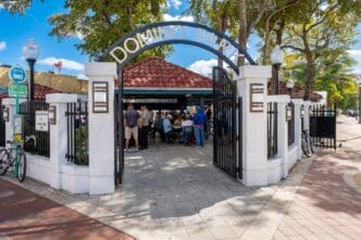
The Little Havana Route is your direct line to Cuban culture. It travels the length of Calle Ocho, dropping you right in the heart of the action. Get off at Domino Park (Máximo Gómez Park) to watch the locals play, then walk to one of the many ventanitas (walk-up coffee windows) for a traditional cafecito and pastelito. The trolley makes it easy to explore the entire neighborhood without worrying about parking.
Tips for a Smooth Ride
To make the most of the trolley system, keep a few practical tips in mind.
- Plan Ahead: Always use the real-time tracking apps to check route maps and arrival times. Operating hours can vary by route and day of the week, so confirm that the trolley is running when you need it.
- Be Patient: The trolleys operate on city streets and are subject to the same traffic as cars. During rush hour or special events, expect potential delays.
- Understand Connections: The trolley system is a powerful tool on its own, but it is even better when used to connect with other forms of public transit like the Metrorail and the free Metromover.
- Practice Good Etiquette: These trolleys are a popular and vital service for many local commuters. Be courteous, move to the back to make room for others, and offer your seat to elderly or disabled passengers.
Ultimately, Miami’s network of free trolleys is more than just a transportation service; it is an invitation to explore. It breaks down barriers, making the city’s most exciting and culturally rich neighborhoods accessible to everyone. Whether you are a tourist on a budget or a local looking for a new way to get around, hopping on a trolley is one of the smartest and most enjoyable ways to experience the Magic City.