Tropical Storm Sara has dissipated, yet its remnants pose potential weather impacts for Florida and the Gulf Coast this week.
Although Tropical Storm Sara has ceased to exist as a formal storm, it continues to influence weather patterns. The storm previously unleashed up to 40 inches of rain in Honduras. The National Hurricane Center issued its final advisory on Sara at 3 a.m. CST, cautioning that more rain could affect northern Honduras, raising the risk of life-threatening floods, particularly near mountainous regions.
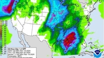
While the storm’s core has weakened, the residual moisture and rain are set to affect Florida and the northern Gulf Coast. The National Hurricane Center along with AccuWeather forecasters indicate the possibility of heavy rains over the coming days in these areas. The Atlantic hurricane season, which is set to conclude on November 30, still leaves room for more developments, though the current tropical conditions appear calm.
Sara’s transition into the Gulf of Mexico as a tropical rainstorm brings about new challenges. A cold front advancing across the United States is pulling some of Sara’s moisture northward, which can heighten rain chances along the Gulf Coast. This interaction is projected to result in landfall in Florida by Wednesday morning, according to experts.
Dr. Ryan Truchelut notes that the Panhandle could experience intense rains and storms starting late Tuesday. These conditions might continue to spread southward across Florida on Wednesday. AccuWeather expert Alex DaSilva forecasts that a stretch from eastern Louisiana to the Florida Panhandle might see flooding downpours with rainfall amounts reaching 2 to 12 inches. Furthermore, wind gusts could reach 40 to 60 mph, especially at the coast during intense downpours.
The interaction of Sara’s remnants with the cold front might also spark isolated tornadoes and severe thunderstorms, mostly likely affecting the Florida Peninsula. Dangerous rip currents are anticipated along the Gulf Coast from Monday through Wednesday.
Currently, there are no other active systems in the Atlantic basin, and with the forthcoming cold front, any immediate threat from tropical systems to the U.S. might be minimized for the remainder of the year.
Although Sara has dissipated, Florida and the Gulf Coast should remain vigilant for heavy rainfall and severe weather potential as the remnants of the storm interact with advancing cold fronts.
Source: News-journalonline


