Landslides in the Los Angeles area have been a known issue for decades, but NASA’s radar technology is now uncovering intriguing details.
Recent data from airborne radar reveal that landslides on the Palos Verdes Peninsula are moving faster and affecting more areas. This discovery raises concerns about the impact on local communities and infrastructure.
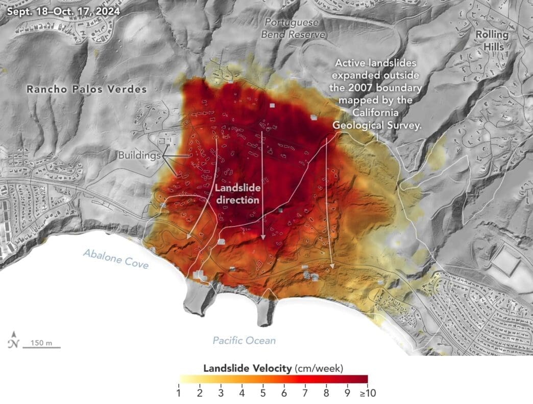
The Expanding Landslide Zone
On the Palos Verdes Peninsula, landslides have carved a path over the years, and recent radar imagery shows they are on the move again. Data from the fall of 2024 indicates a dramatic shift, with some areas sliding up to 4 inches a week. Homeowners are understandably worried, as their properties inch closer to the edge.
Heavy rainfalls in consecutive years played a significant role in the landslide acceleration. The record-breaking rain in 2023 followed by a wet start to 2024 set the stage for this natural event to unfold. Such conditions make landslide monitoring essential, as California grapples with unpredictable weather patterns.
NASA’s Advanced Radar Tools
NASA’s cutting-edge UAVSAR radar was essential in capturing the movement of these landslides. Mounted on a Gulfstream III jet, the radar flew multiple missions to record the landslide activity in detail. This technology helps scientists understand not just the speed but the direction of the landslides, providing a comprehensive view.
Four flights were conducted between September 18 and October 17, capturing crucial data. The UAVSAR’s high resolution allowed for precise measurements of the landslide zones, offering insights that ground observations couldn’t.
The radar data highlighted areas of rapid movement, depicted in dark red hues. These insights are crucial for California officials who must assess risks and plan for potential impacts on infrastructure.
Impacts on Local Communities
As the landslides continue, local communities face mounting challenges. Hundreds of buildings on the peninsula have been identified as being in danger from these natural forces. This slow but persistent movement of land can lead to costly damages and affect the safety of residents.
Residents depend on detailed reports and analyses to make informed decisions about their properties. The data provided by NASA aids in understanding the evolving risks, potentially averting disaster.
With landslide zones expanding, local authorities are on high alert, coordinating with scientists to monitor changes closely.
ARIA and UAVSAR: A Collaborative Effort
NASA’s ARIA project works with Caltech to harness the power of UAVSAR and other tools. This partnership is about more than just landslides; it’s a broader effort to study natural hazards worldwide.
ARIA’s scope includes earthquakes and volcanoes, allowing for swift responses to disasters. This collaboration merges data from various satellite systems, enhancing the accuracy and applicability of findings.
The partnership between NASA and these institutions showcases the blend of radar and optical technology with GPS and seismic data, creating a robust framework for environmental monitoring.
Insights from the UAVSAR Flights
The UAVSAR missions provided pivotal data necessary for understanding the shifting landscape of the Peninsula. These flights allowed researchers to see changes in three dimensions, crucial for disaster response planning.
The dark red areas in the imagery signify higher velocities of movement, crucial information for predicting future slides. Knowing these risk zones can save lives and mitigate damage.
Researchers are keen on expanding this technology’s use, seeing its application across various terrains subject to landslide risks. The initial findings alone highlight UAVSAR’s potential.
Future Implications and Actions
The insights gained from UAVSAR flights are essential for future planning. As the climate changes, so do the landscapes, mandating continuous monitoring and research.
California’s officials use this data to enforce safety regulations and develop land-use strategies that consider potential landslides. This proactive approach can prevent future calamities and save both lives and resources.
With radar technology advancing, researchers foresee real-time monitoring enhancements, allowing immediate reaction to changing conditions.
The Broader Impact of Data Sharing
The analysis data is available to the public, contributing to a broader awareness and understanding of environmental changes. This transparency ensures communities stay informed and prepared.
By sharing findings with officials and the public, communities can make proactive choices, adapting infrastructure and living arrangements accordingly. This shared knowledge base is a powerful tool in mitigating natural disasters.
NASA’s effort in integrating and sharing detailed analytics boosts global preparedness against a host of natural hazards.
The Role of UAVSAR in Climate Change Studies
NASA’s Landslide Climate Change Experiment will extend the use of UAVSAR in studying environmental impacts. This research will focus on how extreme weather influences landslides, a growing concern in today’s climate scenarios.
Projected flights over California’s coastal slopes will provide new data, essential for refining current models of landslide activity in various climate conditions.
This future research underscores the need for ongoing adaptation as global weather patterns shift, emphasizing the long-term value of technology like UAVSAR.
Looking Ahead
As science and technology evolve, so does our ability to predict and prepare for natural events like landslides. UAVSAR and ARIA’s work exemplifies the potential of these advancements.
Future collaborations aim to increase the accuracy of predictive models, vital for effective disaster response plans. By anticipating changes before they occur, communities can remain safe and resilient in the face of natural forces.
NASA’s radar technology offers a powerful tool to understand and mitigate the risks of landslides. Through continued research and collaboration, we gain valuable insights that help protect our communities from natural hazards.