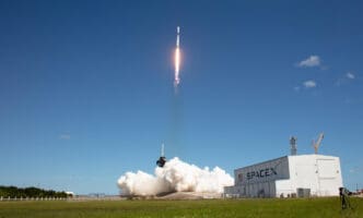

Can you imagine a time when we knew more about Venus’s surface than our own Earth’s? This was the reality before NASA’s groundbreaking STS-99 mission. On February 11, 2000, the space shuttle Endeavour launched the Shuttle Radar Topography Mission (SRTM), setting out to capture the most detailed 3D maps of our planet ever created.
STS-99’s mission was no ordinary journey. Led by an international team of astronauts, Endeavour soared through space on its 14th expedition to give scientists an unprecedented look beneath the Earth’s cloud cover. It was high stakes, high tech, and an inspiring example of global collaboration in space exploration.
The Visionary Crew
The STS-99 team was a mix of seasoned astronauts and innovative thinkers from around the globe. Commanded by Kevin Kregel, the crew included talented individuals like Pilot Dominic Gorie and Mission Specialists Janet Kavandi and Janice Voss. International collaboration brought German astronaut Gerhard Thiele and Japan’s Mamoru Mohri to the mission, blending diverse expertise in an ambitious project.
Selected at different periods, the crew members had varied experiences. For instance, Kregel had three prior spaceflights, while it was Thiele’s first. Janet Kavandi and Dominic Gorie had previously worked together. Each brought unique skills that were crucial in handling the mission’s technical demands and teamwork under the immense pressures of space travel.
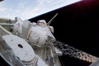
The Breakthrough Technology
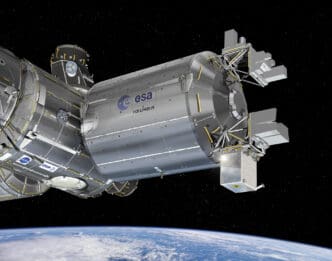
STS-99 employed a cutting-edge technology known as radar interferometry to map Earth’s topography. Unlike past missions, the SRTM used two radar instruments, one mounted on a 200-foot expandable mast, to achieve unprecedented resolution. This setup allowed them to acquire topographic data previously unimaginable.
These advanced radars had previously been tested in the STS-59 and STS-68 missions. However, STS-99 was different because the instrumentation was enhanced to register elevation data over vast areas, allowing scientists to chart nearly all of Earth’s land masses with new clarity. It was a technological leap that would redefine how scientists perceive Earth’s surface.
Embarking on the Journey
In the prelaunch stage, intense preparation unfolded. The crew gathered at Kennedy Space Center, rolling Endeavour into the Vehicle Assembly Building to prepare for takeoff. On December 13, the shuttle moved to Launch Pad 39A, and in January, the team conducted critical countdown tests.
The build-up was nerve-wracking yet filled with shared excitement. On February 11, 2000, Endeavour finally burst into space, carrying not just human ambition but groundbreaking instruments prepared to change our view of Earth. Inside the shuttle, the crew operated like a well-oiled machine, ready for every challenging moment that awaited them above.
A Space Mission Like No Other
Once in orbit, the crew’s primary task was deploying and managing the SRTM. This involved opening payload bay doors, deploying radiators, and extending the 200-foot mast bearing the sophisticated radar equipment.
The crew handled data collection in shifts around the clock. This constant vigilance meant changing data tapes every 30 minutes and ensuring instruments worked optimally. Their efforts generated 332 high-density tapes, providing more than 222 hours of data and covering 99.96 percent of planned observations, a record in mission efficiency.
Alongside technical duties, the crew captured Earth in stunning detail using handheld cameras. Their photos offered a rare glimpse of Earth’s beauty from space, adding a unique human touch to the mission’s scientific achievements.
The Data Collection Success
By the mission’s 10th day, STS-99 had accumulated an unprecedented volume of topographic data. The process involved reeling in the mast and closing the payload bay, a conclusion to an intense period of collection.
The mission had created a comprehensive mapping of Earth’s surface, surpassing previous limits set by radar technology. From the deserts of the Sahara to the lush landscapes of the Galapagos, SRTM had captured it all, producing three-dimensional maps that were as scientifically valuable as they were visually stunning.
Educational Impact and EarthKAM
Among the mission’s educational achievements was the EarthKAM project. This initiative allowed middle school students worldwide to engage with the shuttle’s journey, taking photographs of Earth from space, fostering a unique connection between astronautics and education.
The EarthKAM project linked schools to the mission, with 75 participating globally, offering a wealth of educational opportunities. The students’ involvement brought the wonders of space exploration into classrooms, inspiring the next generation of scientists by turning a space mission into a global educational event.
STS-99 uniquely combined a passion for exploration with dedication to science education. It wasn’t just about data. It was a mission of inspiration, connecting the dots between Earth and the awe of space exploration.
Bringing It Home
After 11 days in orbit and 181 trips around the Earth, Endeavour returned home. Kevin Kregel piloted a flawless landing at Kennedy Space Center, bringing back not just the crew but the culmination of years of collaboration and technological achievement.
Their welcome was filled with celebration but also reflection, acknowledging the transformative work they had completed. It wasn’t just the physical return that mattered but the vast legacy in topography data. STS-99’s success was more than an 11-day trip; it redefined how humanity understands Earth’s surface.
The Lasting Legacy
STS-99 stands as a monumental achievement in aerospace history. By generating over one trillion data points, it provided 12.3 terabytes of 3D Earth data, a treasure trove for scientific exploration.
Its success demonstrated the power of international cooperation and innovative technology. Today, maps from the mission still serve scientists, planners, and educators, a testament to its enduring impact. The mission illustrated the great strides humans can make when they work together towards a common goal.
This mission was not just one small step for NASA. It was a giant leap in our quest to uncover the mysteries of our planet, with September 11, 2000, marking an advance that continues to benefit science and society today.
Reflecting on the Mission
STS-99 was less about the destination and more about the journey. From its launch, the mission was about innovation, discovery, and human curiosity.
The operation pushed boundaries, showcasing the potential to map the unknown with a level of detail once deemed impossible. The radar technology employed set a new standard for Earth observation from space, achieving objectives that were previously out of reach.
STS-99 changed the landscape of Earth observation forever. It wasn’t just a mission; it was a daring quest that proved what we are capable of. With its advanced technology and inspiring international collaboration, it paved the way for future explorations and set a new standard for ambitious scientific missions.