

While coastal communities are still shaking off the remnants of last year’s freak weather, meteorologists are already eyeing the horizon with suspicion. Meteorologists from the renowned Colorado State University (CSU) predicted on April 4 that the 2024 hurricane season will not only be active, but “extremely active”. With a 62 percent chance of a major hurricane making landfall on the US coast, this poses a significant risk to areas prone to these devastating storms.
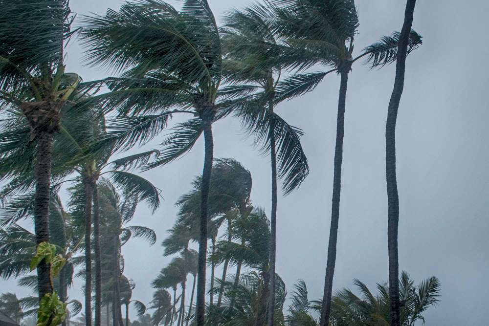 View from below of palm trees swaying in the intense gusts of a Florida storm
The Science Behind the Probabilities
Meteorologists use sophisticated models to determine these probabilities. By analyzing current conditions and comparing them to past data, they can identify patterns that indicate an active hurricane season. The 62% probability isn’t made up out of thin air – it’s based on rigorous scientific analysis and represents a consensus among experts.
Unprecedented Prediction by Experts in the State of Colorado
 Hurricane Ian destroyed roofs of suburban homes in a Florida mobile home community
For nearly 30 years, Colorado State University (CSU), the leader in tropical storm forecasting, hasn’t predicted more than nine hurricanes in its early April forecasts. This year, however, there is a clear deviation from this trend. The college’s experts predict that the 2024 hurricane season could exceed that number, indicating an extraordinary level of concern among some of the world’s most respected meteorologists.
Click here to read the CSU 2024 researchers’ forecast
Drivers of the 2024 Hurricane Season Forecast
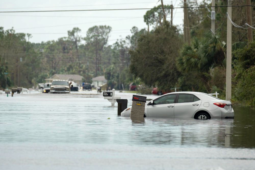 Flooded street with trapped car in a residential area in Florida after the hurricane made landfall
The forecast for an ‘extremely active’ 2024 hurricane season is driven by two main factors that have meteorologists on high alert:
1. Rising Temperatures in the Atlantic
The surface temperature of the Atlantic is one of the most important factors for hurricane development. Warmer water can give storms more energy, allowing them to develop into larger hurricanes. Current temperature measurements show that the Atlantic is unusually hot, which creates optimal conditions for hurricanes to form and strengthen.
In recent months, sea surface temperatures in the Atlantic’s main development zone, which stretches from the African coast to the Caribbean, have been several degrees higher than usual. This is according to information from Brian McNoldy, a research associate at the University of Miami.
The current sea temperatures in this region correspond to the values normally observed in mid-June. If the warming of the Atlantic surface waters continues gradually, the ocean is still on track to reach unprecedented temperatures during the peak of the hurricane season.
2. The Influence of La Niña
In 2023, there was a climate battle between warm ocean temperatures, which are known to intensify hurricanes, and the presence of an El Niño phenomenon, which tends to suppress such storms, making predictions for the 2023 hurricane season particularly difficult.
In conjunction with these warm oceanic conditions, meteorologists expect a La Niña weather pattern for 2024. La Niña is characterized by, among other things, cooler sea surface temperatures in the central Pacific and changing wind patterns in the Atlantic. These changes can reduce the wind shear that often inhibits the development of hurricanes, opening the door for more frequent and stronger tropical cyclones.
Over a three-decade period, there have been 105 major hurricanes in La Niña years, compared to only 45 in El Niño years. In addition, La Niña years increase the likelihood of a storm causing more than $10 billion in damage, with Florida particularly at risk.
Many hurricane forecasting systems in North America use extensive historical data to predict the occurrence of a La Niña event, which coincides with the peak of the hurricane season in August.
The Report on the 2024 Hurricane Season at a Glance
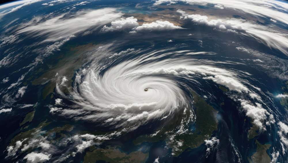 View of a Hurricane from Space
Understanding these sobering forecasts is critical for anyone potentially at risk. Here’s what you need to know from the CSU’s latest report:
- Increased hurricane activity: the predicted increase in hurricane activity for 2024 should be taken as a serious warning. Coastal residents and authorities should prepare for more frequent and potentially stronger storms.
- Preparation is key: Given the likelihood of above-average hurricane activity, comprehensive preparedness strategies are more important than ever. This includes community-wide disaster planning, individual emergency kits and evacuation preparations.
- Staying informed is important: Keeping up to date with the latest weather data, forecasts and recommendations can make the difference between being caught unprepared and being able to take proactive measures to protect lives and property.
The importance of the CSU’s forecast cannot be overstated. As we approach the peak of the 2024 hurricane season, increased awareness and proactive measures are key to getting through this potentially historically difficult time for affected regions.
Hurricane Exposure: Vulnerability Assessment of Coastal and Inland Regions of the USA
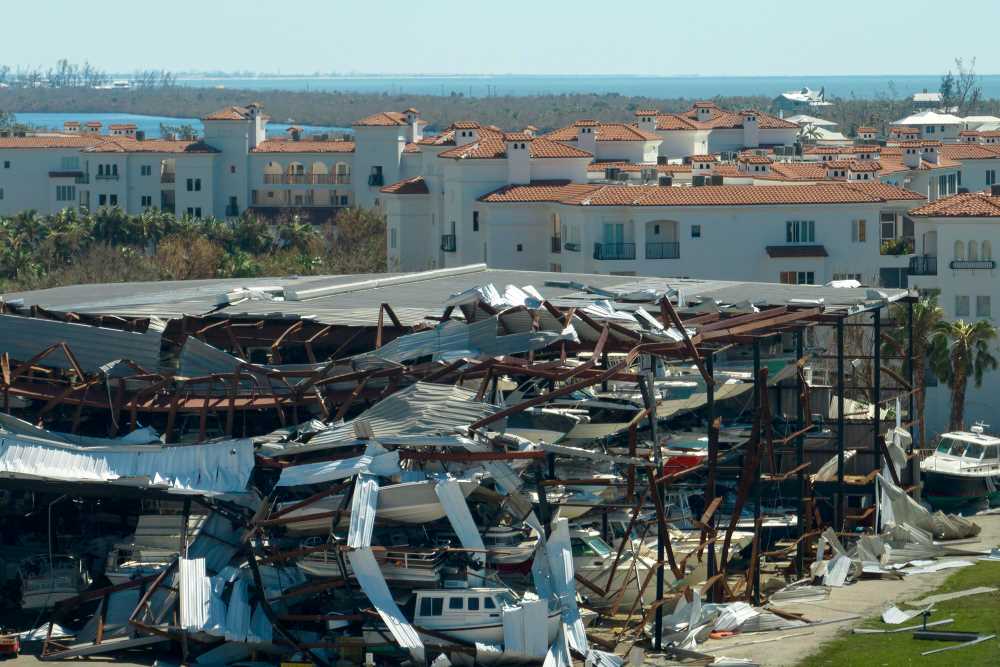 Destruction of Hurricane Ian at the boat station in the coastal region of Florida
An extremely active hurricane season can affect large parts of the United States, especially the states along the Atlantic coast and the Gulf of Mexico. Which areas are hit by hurricanes each year depends on a complex interplay of atmospheric conditions, sea temperatures and weather patterns such as the position of the Bermuda High and prevailing winds. However, some regions are traditionally more susceptible to these powerful storms:
Atlantic Coast
- Florida: Virtually the entire state, including the Gulf and Atlantic coasts, is a frequent target for hurricanes. South Florida, the Keys and the greater Miami area are particularly vulnerable due to their location on the coast.
- Georgia: The coastal areas and especially the low-lying regions around Savannah can get caught in the path of hurricanes coming off the Atlantic.
- The Carolinas: Both North and South Carolina, with their extensive coastlines, have experienced significant impacts from hurricanes in the past.
- Virginia: The low-lying Hampton Roads area in particular could be affected by storm surge and high winds.
- Mid-Atlantic States: States such as Maryland and Delaware may also be affected by hurricanes. By the time the storms reach these areas, they have usually weakened somewhat.
- Northeastern states: States like New Jersey, New York and even all of New England (including Massachusetts and Connecticut) can be at risk from hurricanes, as storms like Hurricane Sandy in 2012 have shown.
Gulf Coast
- Texas: The Texas coast, especially from Galveston to Corpus Christi, is a frequent landfall area for Gulf hurricanes.
- Louisiana: With its low-lying coastline and the Mississippi Delta, Louisiana is particularly susceptible to devastating storm surges and flooding from hurricanes.
- Mississippi and Alabama: Although these states have smaller coastlines, they can still be severely affected by storm surges and winds from Gulf hurricanes.
- Florida Panhandle: Hurricanes that enter the Gulf of Mexico sometimes move east and hit the Florida Panhandle, such as Hurricane Michael in 2018 and the devastating Ian in 2022.
It’s important to note that hurricanes can also have an impact inland, causing heavy rainfall, flooding and wind damage far from their landfall. States like Tennessee, Arkansas and even Missouri can feel the remnants of these storms. In addition, the path and intensity of each hurricane can vary greatly, so it’s not just coastal regions that need to be on alert. Inland flooding is often a deadly and destructive side effect of these storms.
Impact of an Active Hurricane Season on Florida’s Lifestyle, Economy and Tourism
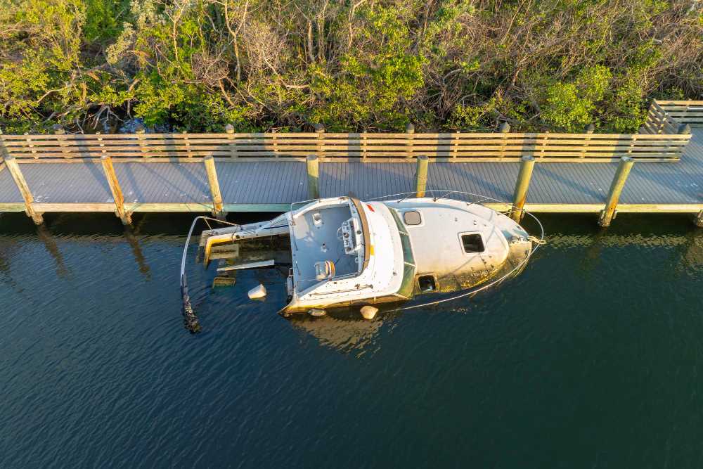 Capsized, sunken sailboat in the shallow waters of the bay after Hurricane Ian in Manasota, Florida
Florida, with its beautiful beaches and lively attractions, faces the challenges of hurricane season every year. Hurricanes are part of the tropical climate, but they have a far-reaching impact on daily life, the economy and tourism. Residents prepare for disruption and possible evacuations. The economy suffers from the damage the storms cause in various industries such as agriculture and real estate. Tourism also suffers as potential visitors choose other locations. We want to explore the complex effects of hurricanes on Florida and find out how people and authorities are working to limit the damage and recover with all their might.
Lifestyle Adjustments in the Face of the Increasing Threat of Storms
For Florida residents, the rituals of hurricane preparedness are nothing new, but an “extremely active” hurricane season like the one predicted for 2024 could require significant lifestyle changes. Residents could face more frequent disruptions, including forced evacuations, power outages and property damage. In South Florida and Miami, this could mean installing hurricane shutters, reinforcing roofs and regularly restocking their hurricane kits with supplies. Year-round vigilance and a greater emphasis on community resilience programs could become the norm as residents adjust to living under the constant threat of the next big storm.
Economic Impact of a Hyperactive Hurricane Season
The economic impact of an intensified hurricane season on Florida could be severe. Property damage could run into the billions of dollars, which could strain insurance companies and lead to higher premiums for homeowners. Businesses, especially small, local businesses, could face business interruption, inventory loss and rebuilding costs. The state’s agriculture industry could also be hit hard as crop damage leads to losses for farmers and higher prices for consumers. The cumulative effect of these factors could impact Florida’s entire economy, slowing growth and potentially leading to job losses in affected industries.
The Tourism Industry is at the Mercy of the Weather
Tourism, a cornerstone of Florida’s economy, is particularly vulnerable to hurricanes. Even the mere threat of a major storm can deter visitors, leading to booking cancelations and a drop in tourist spending. Attractions such as the beaches in Miami, the theme parks in Orlando and the Florida Keys could see a drop in visitor numbers, especially during a potentially prolonged hurricane season. The hospitality and service sectors, which rely heavily on tourist dollars, could face economic difficulties and staffing shortages.
Local and state governments and the tourism industry would need to invest in robust marketing campaigns to reassure potential visitors of Florida’s safety and preparedness. In addition, businesses may need to implement flexible cancelation policies to maintain consumer confidence.
Implications and Preparations
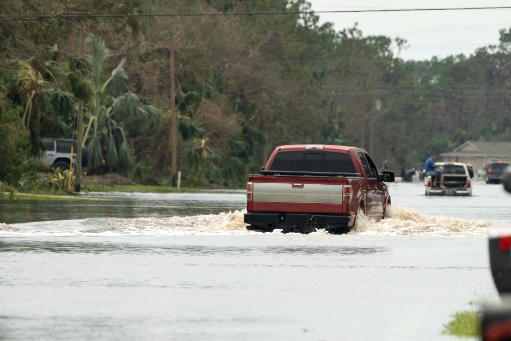 Cars drive through flooded streets in a Florida neighborhood after torrential rains from a hurricane
The implications of an “extremely active” hurricane season are far-reaching. Severe hurricanes (Category 3 and above) can cause catastrophic damage to infrastructure, displace people and overwhelm emergency services and supplies. A season of heightened activity exacerbates these challenges and requires increased preparedness from authorities and citizens.
Preparedness measures include reviewing evacuation plans, reinforcing structures, stocking emergency supplies and reviewing insurance policies. Coastal communities are advised to begin these preparations well in advance of the peak of the season, which traditionally lasts from August to October.
A Call to Action
The CSU’s forecast is not only a warning, but also a call to action. We need to prepare for the possibility of more frequent and more severe weather events. It is important to tighten building regulations, invest in resilient infrastructure and support climate protection measures. In addition, accurate communication and public awareness campaigns are essential to ensure people understand the risks and are prepared to act when a storm hits.
Conclusion: Vigilance is Key
The forecast for the 2024 hurricane season may seem scary, but it reminds us of the importance of vigilance and preparation. The force of nature is humbling and unpredictable, but with the right measures, we can mitigate the impact and protect our communities. Stay informed, stay prepared and together we will weather the storm.


