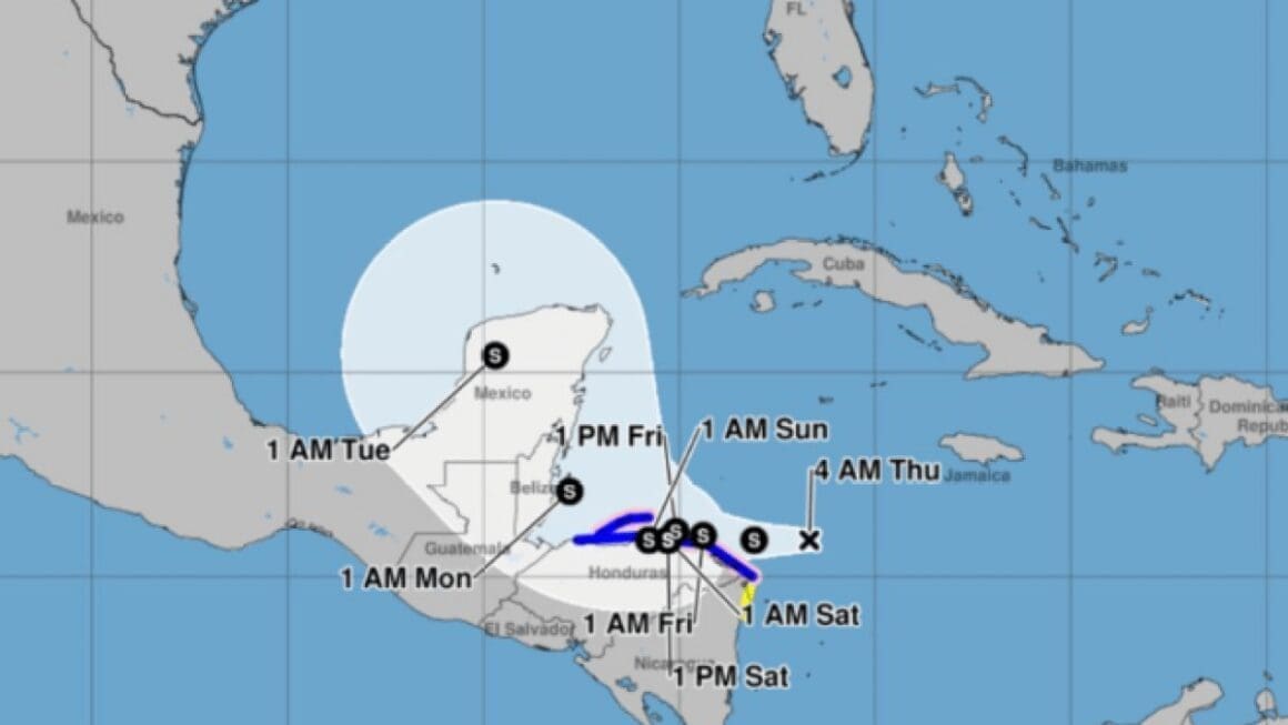
Tropical depression 19, recently formed in the western Caribbean, is under close scrutiny as it could potentially impact Florida by next week. The system is currently less than 90 miles from the coastlines of Nicaragua and Honduras, leading to the issuance of hurricane and tropical storm watches and warnings for these regions.
The development of tropical depression 19 has drawn significant attention due to its proximity to Central America and its potential trajectory towards the United States. Currently moving at 15 mph, the system is expected to slow down, posing a concern for the areas directly in its path. The expectation is for substantial rainfall, possibly reaching up to 30 inches, which could result in dangerous mudslides and landslides in the affected regions.
Meteorologists are closely monitoring the interaction between the cyclone and the landmass, as this will play a crucial role in determining the system’s strength. The cyclone’s journey along the Nicaraguan coast is expected to continue for a few days, while land interactions could prevent it from becoming a more severe hurricane. This interaction, however, does not eliminate the risk of heavy rainfall and related hazards.
[twitter-embed-display twitter_url=’https://twitter.com/NWSMiami/status/1856986195173281975′]
Looking ahead, the system is predicted to move northward, eventually entering the Gulf of Mexico. The potential impacts on Florida remain uncertain at this point. The strength and positioning of the jet stream will be pivotal in directing the depression’s path. Current models suggest that strong upper-level westerly winds might steer the cyclone into the eastern Gulf by mid-next week. However, the exact impact on Florida, including intensity and location, remains unclear.
The challenge in forecasting lies in predicting the short-term strength of the cyclone, influenced by how much it interacts with land. A stronger system is likely to follow higher atmospheric winds, whereas a weaker one may be guided by lower-level winds. This complexity, coupled with the dynamic position of the jet stream, contributes to the uncertain forecast for the region.
Residents in potential impact areas are advised to remain vigilant and keep abreast of updates from the National Weather Service and local meteorological sources. The unpredictable nature of tropical systems necessitates caution and preparedness, as conditions can evolve rapidly.
While the potential effects of tropical depression 19 on Florida are still being assessed, the system’s trajectory and strength remain key factors in determining its ultimate impact. Continuous monitoring and preparedness are advised for those within possible affected regions. As the situation develops, staying informed through reliable sources is crucial.


