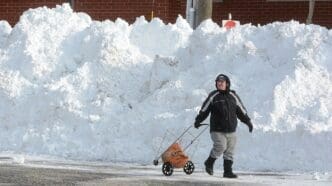
The Great Lakes snowbelts are synonymous with some of the most extreme snowfall incidents globally, producing staggering amounts of snow within short timeframes. Recent records, particularly prevalent in regions like upstate New York, demonstrate the power of lake-effect snow.
Cold air masses from Canada interact with the warmer, unfrozen surfaces of the Great Lakes, leading to intense snow events. This phenomenon is responsible for substantial snowfall, particularly highlighted by NASA’s imagery which captured vast snowbands over the region on January 5, 2015.
The record 24-hour snowfall in New York was 50 inches on February 1, 1966, in Camden. Nearby areas have experienced even heavier snowfalls, with Adams and Barnes Corners recording 68 and 54 inches in a single day respectively in 1976. The perpetual unfrozen state of Lake Ontario throughout winter facilitates these lake-effect snowstorms, often reaching three to four feet in depth.
In February 2007, Redfield, New York, endured an overwhelming 141 inches of snow over ten days. Similarly, Montague accumulated 127 inches within six days in December 2001. These events emphasize the significant snowfall the region endures, owing to its unique geographical and climatic conditions.
Aside from Lake Ontario, the other Great Lakes, including Erie and Michigan, also contribute to heavy snowfalls. Buffalo, New York, experienced a historic snowstorm in November 2022 and December 2014, with snowfalls exceeding 81 and 88 inches respectively, effectively paralyzing the city.
Lake Michigan and Lake Superior add to regional snowfall, although their totals are often less alarming than those of Lakes Erie and Ontario. However, instances like the January 2011 snowstorm in South Bend, Indiana, illustrate the havoc lake-effect snow can cause, delivering snow at rates of six to eight inches per hour, setting a record of 36.6 inches over two days.
Michigan’s Upper Peninsula is famously snowy, not only due to the lake-induced snowfall but also its geographic elevation. Towns such as Marquette and the Keweenaw Peninsula frequently surpass 200 inches of snow annually, with the 1978-79 season clocking over 390 inches.
The interplay of cold air masses with the warmer Great Lakes creates some of the most impressive snowfall events, as seen through historical and recent records. These phenomena continue to shape the climatology of the regions surrounding the Great Lakes, presenting both challenges and awe-inspiring scenes of winter’s capacity.
Source: Weather


